


Adria Voting District, Tazewell County, Virginia
About
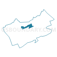
Outline

Summary
| Unique Area Identifier | 682635 |
| Name | Adria Voting District |
| County | Tazewell County |
| State | Virginia |
| Area (square miles) | 13.32 |
| Land Area (square miles) | 13.32 |
| Water Area (square miles) | 0.00 |
| % of Land Area | 99.99 |
| % of Water Area | 0.01 |
| Latitude of the Internal Point | 37.15705130 |
| Longtitude of the Internal Point | -81.57808630 |
Maps


Graphs
Select a template below for downloading or customizing gragh for Adria Voting District, Tazewell County, Virginia


Neighbors
Neighoring Voting District (by Name) Neighboring Voting District on the Map
- Amonate Voting District, Tazewell County, VA
- Bandy Voting District, Tazewell County, VA
- Baptist Valley Voting District, Tazewell County, VA
- Bishop Voting District, Tazewell County, VA
- Gap Store Voting District, Tazewell County, VA
- Jeffersonville Voting District, Tazewell County, VA
- Tip Top Voting District, Tazewell County, VA
Top 10 Neighboring County Subdivision (by Population) Neighboring County Subdivision on the Map
- Northern district, Tazewell County, VA (9,243)
- Southern district, Tazewell County, VA (9,101)
- Western district, Tazewell County, VA (8,841)